Serhetabat
Serhetabat (formerly Gushgy) (Guşgy; Кушка, Kushka) is a city in Tagtabazar District, Mary Province, Turkmenistan. Serhetabat lies in the valley of the Kushka River. The population was 5,200 in 1991. It is immediately opposite Torghundi, Afghanistan, with which it is connected by a road and a gauge railway.
The name of the city is a Turkmen borrowing from Persian سرحدآباد, consisting of two words: سرحد meaning "border" and آباد meaning "inhabited place" (commonly used as a Persian suffix for naming places, such as Khorramabad, a city in Iran, and Ashgabat, the capital of Turkmenistan). The name of the city corresponds to its geographic location on the Turkmenistan-Afghanistan border. A historical part of the Iranian city Karaj shares the same name, Sarhadabad. Gushgy is a Turkmenized form of the Persian-Afghan word kushk (کوشک), a term referring to mountain forts. In 1885 after taking the Panjdeh oasis Russian troops constructed a fort on the site of present-day Serhetabat and named it for the village of Kush in Afghanistan. The Turkmenistan government changed the name to Serhetabat on 29 December 1999 by Parliamentary Resolution HM-67.
The name of the city is a Turkmen borrowing from Persian سرحدآباد, consisting of two words: سرحد meaning "border" and آباد meaning "inhabited place" (commonly used as a Persian suffix for naming places, such as Khorramabad, a city in Iran, and Ashgabat, the capital of Turkmenistan). The name of the city corresponds to its geographic location on the Turkmenistan-Afghanistan border. A historical part of the Iranian city Karaj shares the same name, Sarhadabad. Gushgy is a Turkmenized form of the Persian-Afghan word kushk (کوشک), a term referring to mountain forts. In 1885 after taking the Panjdeh oasis Russian troops constructed a fort on the site of present-day Serhetabat and named it for the village of Kush in Afghanistan. The Turkmenistan government changed the name to Serhetabat on 29 December 1999 by Parliamentary Resolution HM-67.
Map - Serhetabat
Map
Country - Turkmenistan
 |
 |
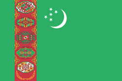
| Flag of Turkmenistan | |
Turkmenistan has long served as a thoroughfare for other nations and cultures. Merv is one of the oldest oasis-cities in Central Asia, and was once the biggest city in the world. It was also one of the great cities of the Islamic world and an important stop on the Silk Road. Annexed by the Russian Empire in 1881, Turkmenistan figured prominently in the anti-Bolshevik movement in Central Asia. In 1925, Turkmenistan became a constituent republic of the Soviet Union, the Turkmen Soviet Socialist Republic (Turkmen SSR); it became independent after the dissolution of the Soviet Union in 1991.
Currency / Language
| ISO | Currency | Symbol | Significant figures |
|---|---|---|---|
| TMT | Turkmenistan manat | m | 2 |
| ISO | Language |
|---|---|
| RU | Russian language |
| TK | Turkmen language |
| UZ | Uzbek language |


